Posts

Showing posts from June, 2022

Module 6 - Working Rasters

Image
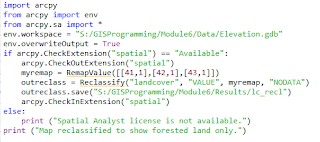
  To say I struggled throughout this course would be quite an understatement! Each week I felt like I would never figure out the correct scripts and somehow each week it would just click suddenly and I was able to complete each assignment with confidence. Unfortunately, my luck ran out with this final module. As before, I worked my way through the exercise without much difficulty and felt like I understood how to accomplish the assignment. I got the first portion to work and was happy that it was going so well. Then, things took a turn. I struggled to figure out why the slope and aspect parts of the script gave me the same error over and over. I had verified by checking ArcGIS Pro and running the code to be sure the Spatial Analyst was licensed but still received a "tool is not licensed" error repeatedly. While I was not able to write a successful script this time I have learned a lot in this course and hope to continue gaining confidence in using coding as I progress with my...

Module 5 - Geometries

Image
Module 5 introduced working with and writing geometries in Python. Again, as last week, I felt good about this topic after working through the exercise but found some difficulty once I got to the actual assignment. I was able to get my code to work correctly in Python quickly, however, I had a A LOT of trouble getting all the features to print into my text file. After many hours, scouring the group discussion, posting my issue in the discussion, and messaging Brittany I finally found success and had a fully functional code! Bring on the last module!  

Module 4 - Exploring and Manipulating Data

Image
This weeks module was especially challenging. I felt good after completing the exercise but struggled quite bit on getting my search cursor to function properly. After A LOT of trial and error I was able to get a working script!  

Module 3 - Geoprocessing

Image
The assignment for this module was quite a rollercoaster for me. I actually went in fairly confident because I had worked through the exercise without too much trouble and had read the assigned chapter. Getting through the model building was not too difficult and actually made a lot of sense to me. I guess because I can see the flow of the processes better than the written scripts.  Once I reached the code writing portion I was ready to jump right in. I made it through adding the XY coordinates and adding the buffer to the shapefile fairly easily. However, dissolving the buffer presented quite a challenge for me. I must have retyped the code as it was done in the exercise 15 times and would get a different error message every time! Luckily at some point it just clicked and the code ran successfully. I have included by script results as well as the map showing the shapefiles. On to Module 4!  

Module 2 - Debug and Error Handling

Image
Script 1 - The goal of Part 1 of this week's module was to identify and correct errors in a given code. The purpose of this code was to print out the names of all fields on the attribute table for a given shapefile. After correcting the case-sensitive code, changing the file path from Module 3 to 2, and making sure all variables were spelled correctly I was able to successfully run the code. Script 2 - Part 2 of this week's module was another exercise in identifying and correcting errors. The purpose of this code was to print a list of available shapefiles located on a map. Again, case-sensitivity and spelling caused errors as well as the correct use of all slashes. Once these corrections were made, the code ran successfully. Script 3 - Part 3 of this module proved to be much more difficult for me than the other two scripts. The goal of this exercise was to for a code to run despite the errors using try-except statements. I had to use trial and error several times before I foun...